|
The story of Ting Tang Lane is best illustrated in three documents
kindly provided by Les Goble
Mr Goble describes Ting Tang Lane as 8m wide, is still regularly
used by ramblers and dog walkers albeit the first 420m can become
very muddy due to agricultural vehicles gaining access to the fields
eastwards. Once past this, the path is full of the wonders of nature
with spectacular views westwards across the rising hills that form
the start of the Cotswolds all of which creates an environment which
is beneficial for the wellbeing of our community. The Cotswold Stone
walls still exist each side of the lane although the first 420m on
the east side has virtually disappeared. However, the base is still
visible.
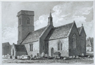
83. Referring to the naming of Ting Tang Lane, he considers two
local theories; the first is that it came from the sound of the
bells around the necks of sheep that were being taken to Abingdon
market, and the second, and far more likely, is that it was the
‘ting tang’ sound made by the single bell mounted in the centre of
St Britius’s Church roof ridge which was used to call the community
to communion. This bell, once cast, was carried by boat up the river
to Worsham and then overland by track to the church. This track
became known as ‘Ting Tang Lane’.
A fully documented history is provided in the document referred
to below.
The first is a draft application undated which provides the
status and background to Ting Tang Lane. See the pdf file
here
The second is an order designating Ting Tang Plane as an official
byway. The document dated November 2019 can be found
here
The third item is a
map |